
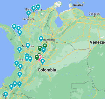
C A R T O G R A F Í AGeoConflictoyPaz |
It is a long established fact that a reader will be distracted by the readable content of a page when looking at its layout. The point of using Lorem Ipsum is that it has a more-or-less normal distribution of letters,
Ir ahora
It is a long established fact that a reader will be distracted by the readable content of a page when looking at its layout. The point of using Lorem Ipsum is that it has a more-or-less normal distribution of letters,
It is a long established fact that a reader will be distracted by the readable content of a page when looking at its layout. The point of using Lorem Ipsum is that it has a more-or-less normal distribution of letters,


© LabMediSocial. Derechos reservados. 2021 | Diseño y desarrollo: Néstor Rojas
Plantilla por: Free html Templates -
Imagenes por: Unsplash
y Myiconfinder